Maps & Location
We are located on the north shore of Lake Nipissing, between the towns of Sturgeon Falls and Verner. The cities of North Bay and Sudbury are 1 hour away on Hwy 17. Cache Bay is only a 5 min. boat ride from camp. Our central location allows easy access to the upper French River, the Hardwood islands and many other islands and bays, the west arm of Lake Nipissing, and the large part of the lake.
Maps of Lake Nipissing:
We give our guests complimentary maps of the area close to camp and we sell official hydrographic maps of Lake Nipissing and the Upper French River.
How To Get Here:
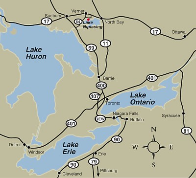
We are approx. 4 hours from Toronto or Ottawa and 5 ½hours from Sault St. Marie. Hwy #11 from southern Ontario is a 4 lane divided highway almost all the way and is the fastest route.
From Toronto:
- Take Hwy. 400 north to Hwy. 11 north
- Take Hwy. 11 north to the city of North Bay
- In North Bay Hwy. 11 becomes Hwy. 17 west
- Follow Hwy. 17 through the town of Sturgeon Falls and 3 km (1.8 miles) past the town, look for the road sign on the right side of the highway for Levac Road and Camp La Plage.
- Turn left at Levac Rd and follow the road. Do not go into Cache Bay. Follow camp signs and after railway tracks on Leclaire Rd, turn left on La Plage Rd. Follow camp signs on La Plage Rd to the end of the road.
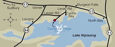
From Hwy. 69 or 64 South
- Going north follow Hwy. 64 through the town of Lavigne.
- Approx. 9.5 km (6 miles) past Lavigne, turn right on Leclaire Rd. If you get to Verner, you have gone too far.
- Follow Leclaire Rd. Turn right at the “Camp La Plage” sign at the corner of La Plage Rd.
- Follow the camp signs from there.
From Sudbury and West
- Follow Hwy. 17 going east to Verner
- Turn at Verner on to Hwy 64 south
- Follow Hwy 64 south to Leclaire Rd, turn left (east) onto Leclaire
- Follow Leclaire to La Plage Rd on the right side of road. You will see the Camp La Plage blue sign on the left side at the intersection
- Follow La Plage Rd. and camp signs to the end
Approx. Driving Distances to Camp La Plage:
- Baltimore, MD 674 mi 1085 km
- Buffalo, NY 327 mi 526 km
- Charleston, WV 726 mi 1168 km
- Chicago, IL 735 mi 1182 km
- Cleveland, OH 530 mi 853 km
- Detroit, MI 454mi 730 km
- Indianapolis, ID 743 mi 1195 km
- Montreal, QC 390 mi 627 km
- New York, NY 720 mi 1160 km
- Ottawa, ON 260 mi 418 km
- Pittsburgh, PA 555 mi 893 km
- Port Huron, MI 419 mi 674 km
- Sault Ste. Marie, ON 242 mi 389 km
- Toledo, OH 536 mi 863km
- Toronto, ON 237 mi 381 km